Smoke haze is a recurring fact of life in Sarawak, not a freak event. Most years, somewhere between June and September, the southwest monsoon carries air north out of Kalimantan and Sumatra — and in a dry year, that air carries the smoke of land and peat fires with it. Some seasons pass with barely a hazy week. Others close schools across nine districts at once.

Why Sarawak gets haze
The fires are largely not in Sarawak. Much of the lowland upwind of us is drained peatland, cut through with canals for oil palm and timber plantations, and drained peat behaves like a deep bed of dry fuel: it catches easily, burns downwards rather than outwards, resists being put out, and produces enormous volumes of fine particulate smoke. A good deal of it is lit deliberately to clear land. Add a drought year — an El Niño, typically — and the season turns severe.
.jpg)
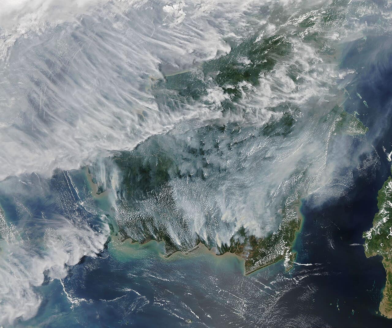
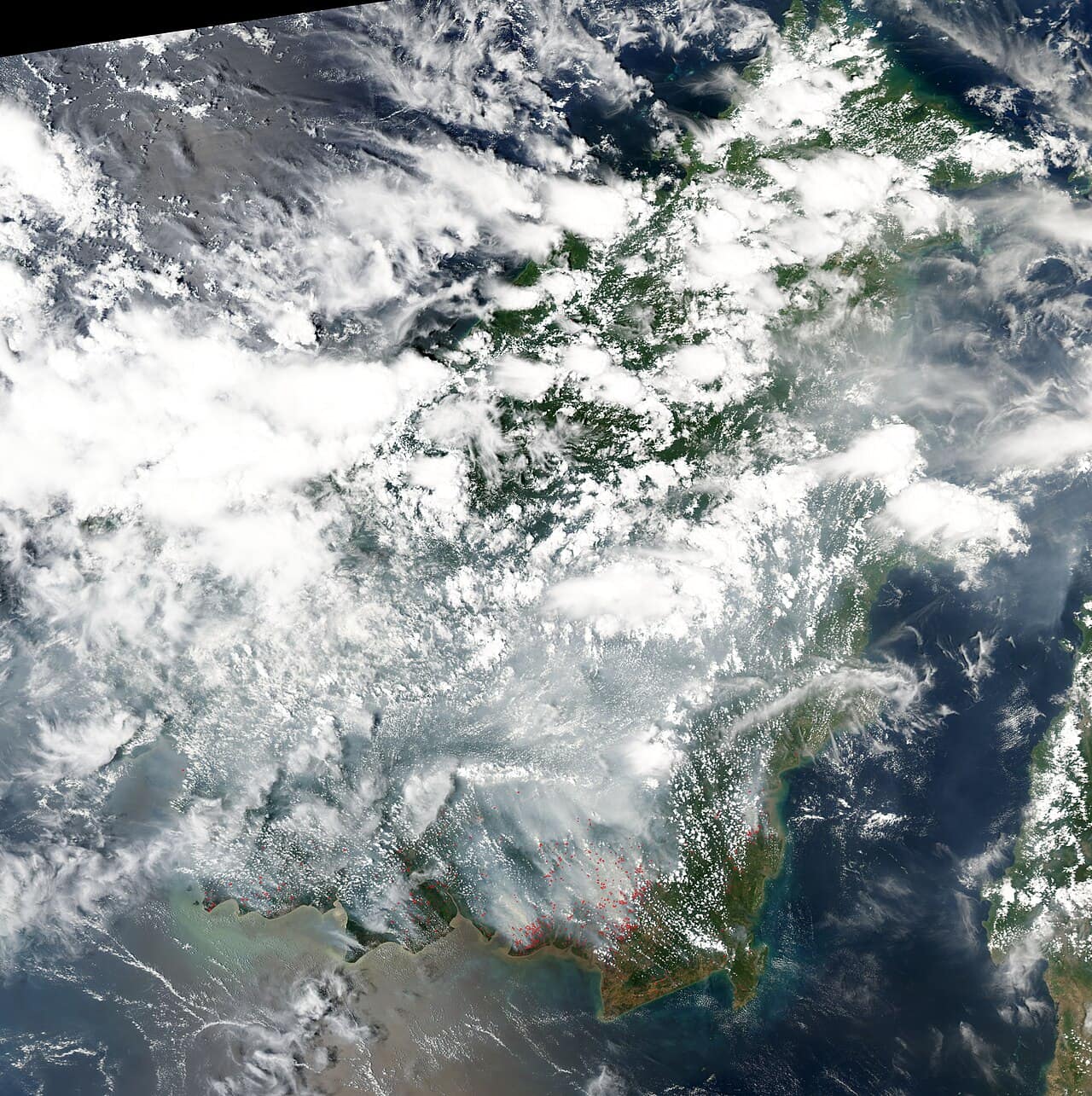
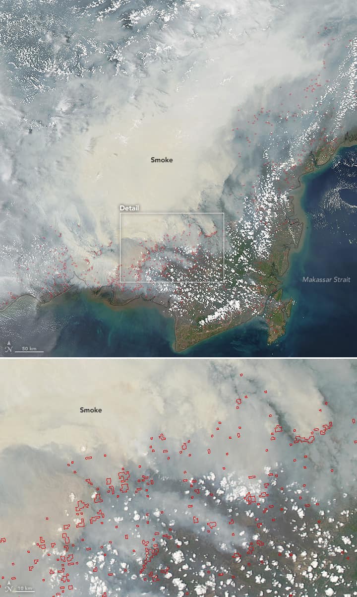
Sarawak sits directly downwind, which is the whole story in one sentence. The satellite view above is the mechanism made visible: fires burning across southern Borneo, and the smoke travelling north over the Malaysian half of the island. Local open burning adds to the load, which is why enforcement notices go out every season, but the bulk of a bad episode arrives from across a border.
.jpg)
Which towns are worst affected
Geography decides it. The south-western divisions closest to the Kalimantan border take the worst of it — Serian and Samarahan routinely top the state table, with Kuching and Sri Aman close behind. The central coast follows a step down: Sarikei, Sibu and Mukah. The northern towns — Bintulu, Miri and Limbang — are usually the last to be affected and the first to clear, which is worth knowing if an itinerary can be reordered rather than cancelled. All ten are on the board above.
How to read the API
Malaysia’s official measure is the Air Pollutant Index, the API, published hourly station by station by the Department of Environment. It runs 0 to 500: under 51 is good, 51 to 100 moderate, 101 to 200 unhealthy, 201 to 300 very unhealthy, and 301 to 500 hazardous. The threshold worth memorising is 100 — once your area passes it, the Health Ministry’s advice is to cut back on physical exertion and time outdoors, and to keep cutting back as it climbs.
The board above is not the API. There is no open, key-less feed of the official index, so rather than print a number we cannot stand behind, it shows the PM2.5 and PM10 concentrations that haze is actually made of, modelled hourly, banded by the US EPA’s AQI. Treat it as a quick sense of the trend between official updates. Two things follow from it being a model rather than a monitoring station: the forecast grid is coarse, so neighbouring towns sometimes fall in the same cell and read identically, and the AQI band runs on a rolling average, so a town can sit a band worse than its current PM2.5 figure alone would suggest. For the reading that school closures are decided on, go to the Department of Environment’s APIMS portal.
Looking after yourself
The short version: an N95, KN95 or FFP2 respirator is the only mask worth wearing — surgical and cloth masks do little against particles this small, and a respirator only works if it seals. Indoors, shut the windows on the worst days, run air conditioning on recirculate rather than fresh-air intake, and stop adding smoke of your own: no cigarettes inside, go easy on incense and mosquito coils, and use the extractor fan when frying. A HEPA purifier makes a real difference in one closed room. Move exercise indoors — hard exertion outdoors means breathing several times as much air, and therefore several times as much smoke.
Young children, older adults, pregnant women and anyone living with asthma, chronic lung disease or heart disease feel a haze day hardest, and outdoor workers take the highest cumulative exposure simply because they cannot go inside. Keep relievers stocked before the smoke arrives rather than on the worst day. New or worsening breathlessness, chest tightness, wheezing a reliever does not settle, a persistent cough or dizziness are all reasons to see a doctor. The full practical guide goes into more detail.
The worst past episodes
September 1997 remains the benchmark. Smoke from the great Indonesian fires of that El Niño year drove the API in Kuching past 800 — still the worst air Malaysia has ever recorded — and Sarawak spent ten days under a state of emergency, with schools and offices closed and flights grounded.
2015 burned for months: fires across Kalimantan and Sumatra in another strong El Niño kept Sarawak in and out of the unhealthy band from August into October, with repeated school closures, in what was judged the region’s worst season since 1997. September 2019 was shorter but sharp — south-western Sarawak spent days at the top of the scale, schools closed across the state, and the satellite photographs on this page were taken. And August 2026 is the season just past: as our own reporting recorded, Serian logged the state’s highest reading at 195, Kuching reached 182, and by 20 August the closure list covered 591 schools across nine districts.
Every one of those episodes ended the same way: not with enforcement or cloud seeding, but with the arrival of steady rain.
How long an episode lasts
Until sustained rain arrives. A wet afternoon buys a day, and the smoke returns when the wind turns — the pattern of every bad season. An episode properly breaks when the monsoon transition brings steady rainfall rather than isolated storms, which in a bad year means late September or October. Cloud seeding is used to take the edge off, but it needs suitable cloud to work with, so it is a tool rather than a switch.
If you are travelling to Sarawak
A hazy forecast rarely justifies cancelling a trip, but it does justify reshaping one. Reduced visibility is the practical problem: flights can run late, and the small rural airstrips are the most exposed — services into Mulu and Bario depend on visual conditions in a way that jets into Kuching and Miri do not. Build slack into anything that hangs on a single connecting flight.
What loses the most is anything you came for the view of: summit walks, Santubong, sunrise from Canada Hill in Miri, a long journey up the Rejang. What holds up entirely is everything indoors or underground — the Borneo Cultures Museum, the Sarawak Science Centre, the caves at Bau, and an unhurried eating tour of Kuching’s kopitiams over laksa and kolo mee.
Where the official information comes from
This is an independent information site, not a government or agency channel. For anything that affects you directly — advisories, school closures, health guidance — follow the Department of Environment, the Ministry of Health and the Sarawak Disaster Management Committee. The APIMS portal is the authoritative source for the API itself.